
Great Basin National Park

After a lovely fall spent in the Rockies, we made our way across state-lines to visit Great Basin National Park in Nevada. At first glance, Great Basin NP seems a bit of a letdown – I have heard the words barren or uninteresting used to describe this area. Even the city of Baker, the closest settlement, seems almost a ghost town (turns out there are 58 people who live in this town). However, from the high alpine tundra and snow covered peak of the 13,063 ft Mt. Wheeler, to the sage-covered foothills and desert valley, Great Basin NP was a surprisingly diverse park. With Great Basin being one of the least visited parks, it seemed like a great way to continue our trip, yet still be cautious of the pandemic and the safety of our family.


One of the first things we did when we arrived was spend an afternoon exploring the Wheeler Peak Scenic Drive. The drive is relatively short – only 12 miles one way. However, in those 12 miles, the road gains nearly 4000 ft of elevation with the end being over 10,000ft above sea level and looking at the face of Wheeler Peak. This is a true mountain road, hugging the steep slopes of the South Snake Range, with narrow hairpin turns, few side rails, and several pullouts that allow you to really take in the vistas of the rugged, harsh, and surprisingly beautiful Great Basin Desert. Due to the extreme changes in elevation, this park supports a diverse range of plants and animals including 11 species of conifer trees, 73 species of mammals (many of which are shrews and bats), 18 species of reptiles, 238 species of birds, 8 species of fish, and over 800 species of plants. In just 12 miles, you traverse the same eco-regions that you would have encountered if you drove from Baker, NV to the frozen Yukon!


As you leave the sagebrush flats of the valley floor, drastic changes happen quickly around 8,000 ft with the low shrubs replaced by the pristine pinyon/juniper woodland – it is not uncommon to see mule deer, coyotes, and jackrabbits crossing the road. At 8,500 ft the pines are quickly replaced by some rather scrappy, rough looking trees, known as Curleaf Mountain Mahogany. There is another noticeable change here – unlike the lower elevations that seem desolate from human contact, large areas of Mountain Mahogany were cleared to support early miners in the area, and the human impact is easily seen.
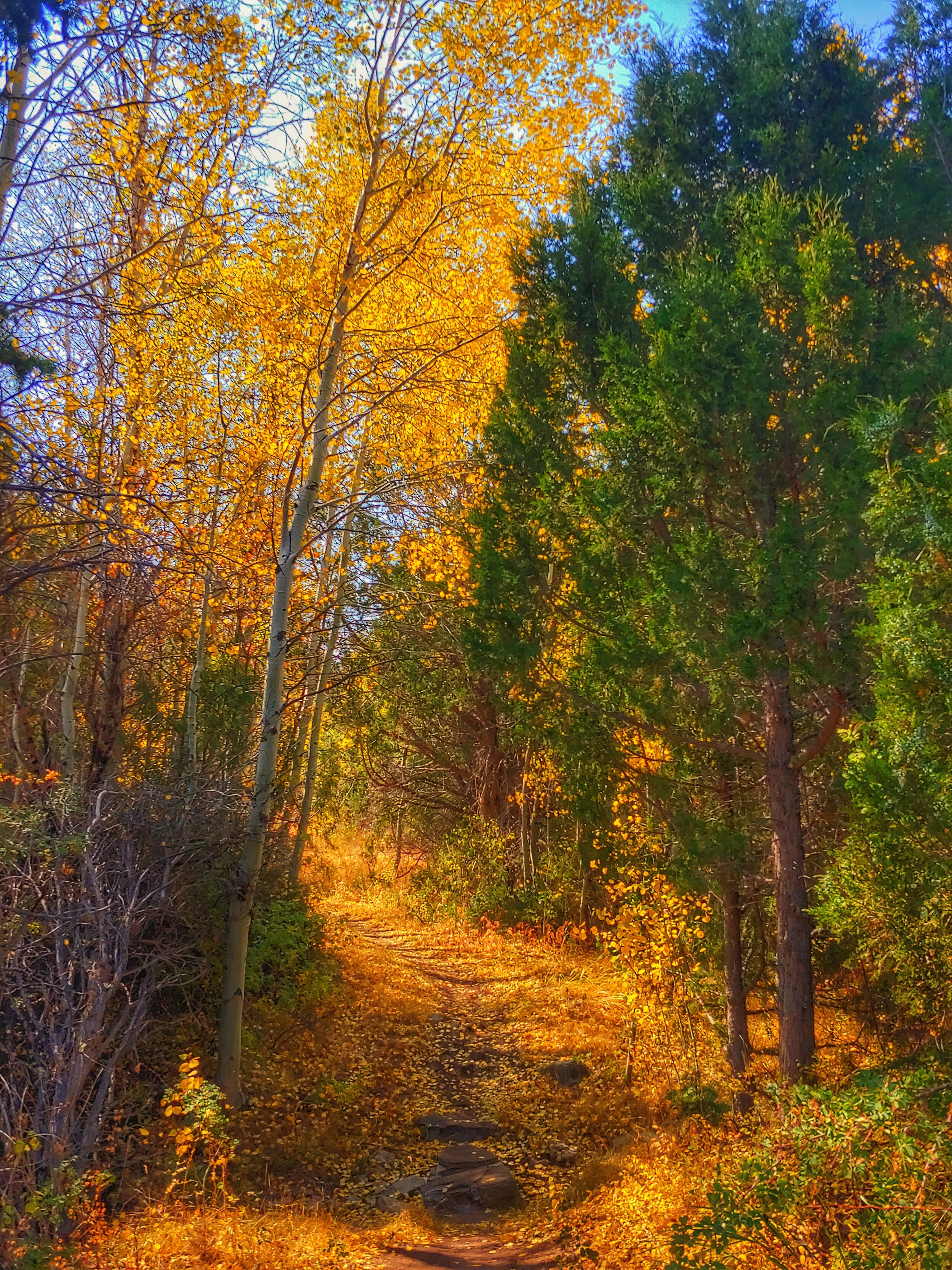
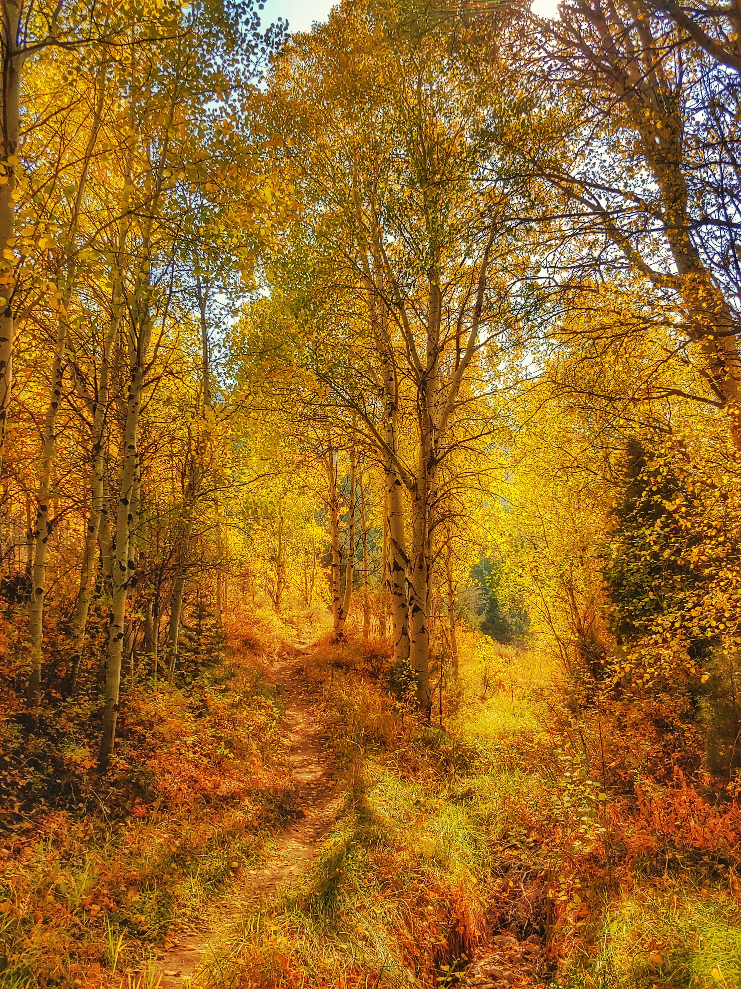
By 9,000 ft you have once again switched eco-zones and entered a forest of mixed conifers. Groves of White Fir, Douglas Fir, and Ponderosa Pine spread over the dry rocky slopes and the vegetation begins to thin as you near tree line. By the 11th mile, we began to feel a bit of déjà vu as we entered an eco-zone more characteristic of the Rocky Mountain alpine forests we had just left behind. Dominated by white-barked aspen trees, we were taken aback at the beautiful fall foliage we were seeing in an area we assumed would be barren desert! I was surprised to learn that each aspen grove we saw dotted along the mountain slope was a single, living organism. Aspens reproduce through cloning by sending runners out underground that become “new trees.” As such, it is common that entire hillsides of aspens are all a single, genetically identical tree (mind blown, science is awesome!).

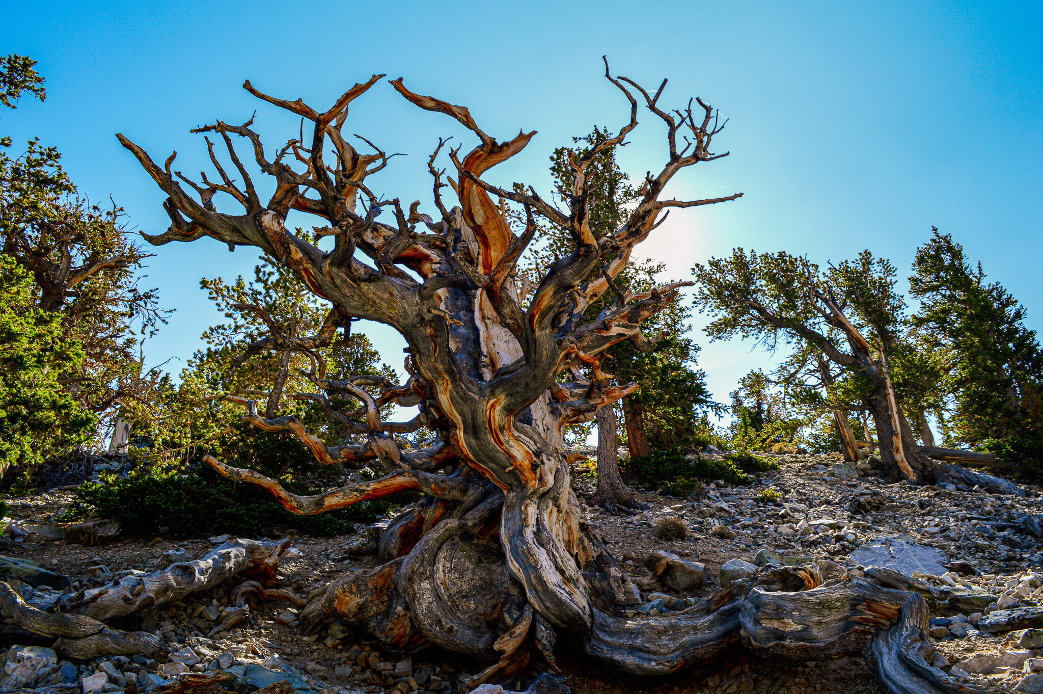
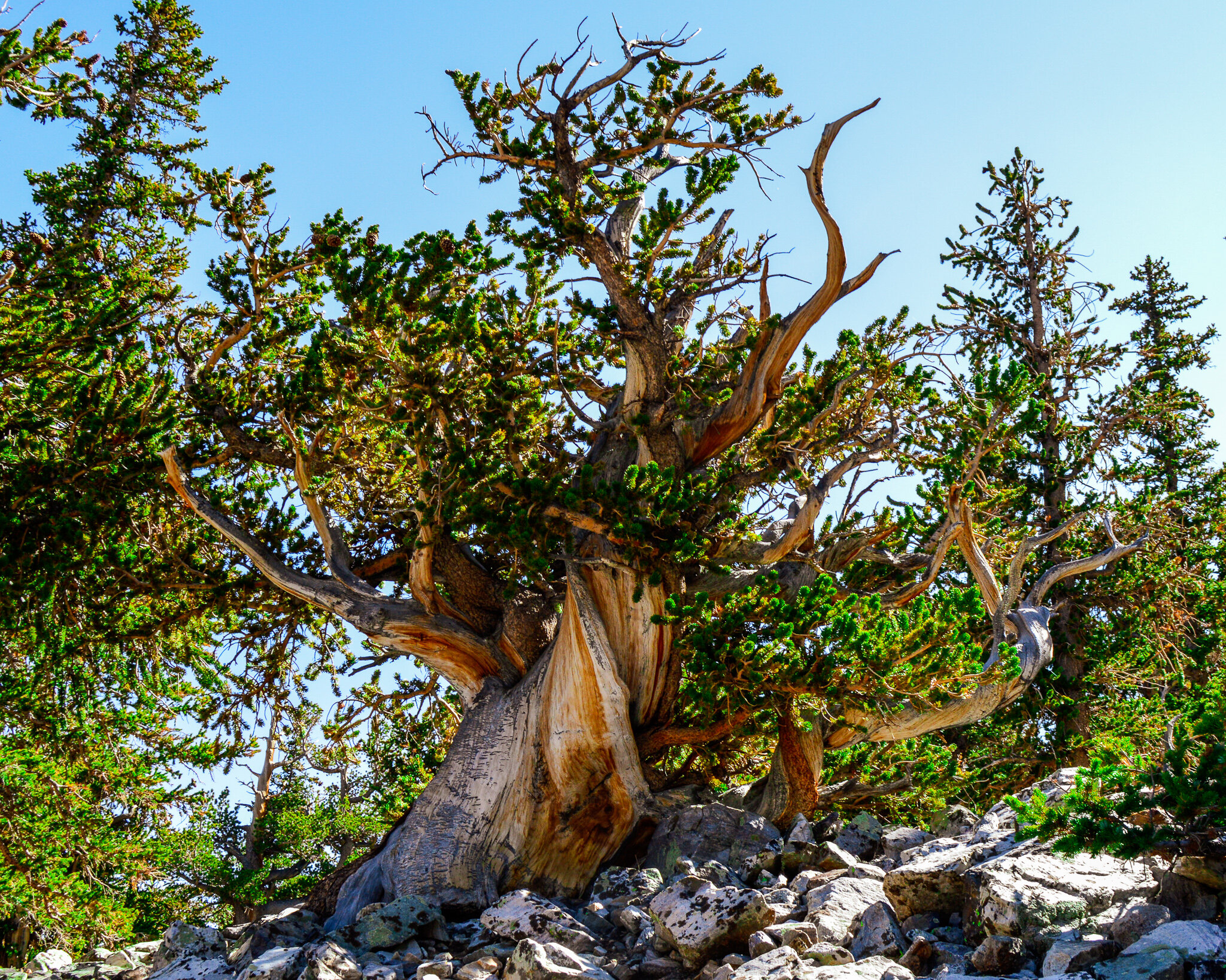
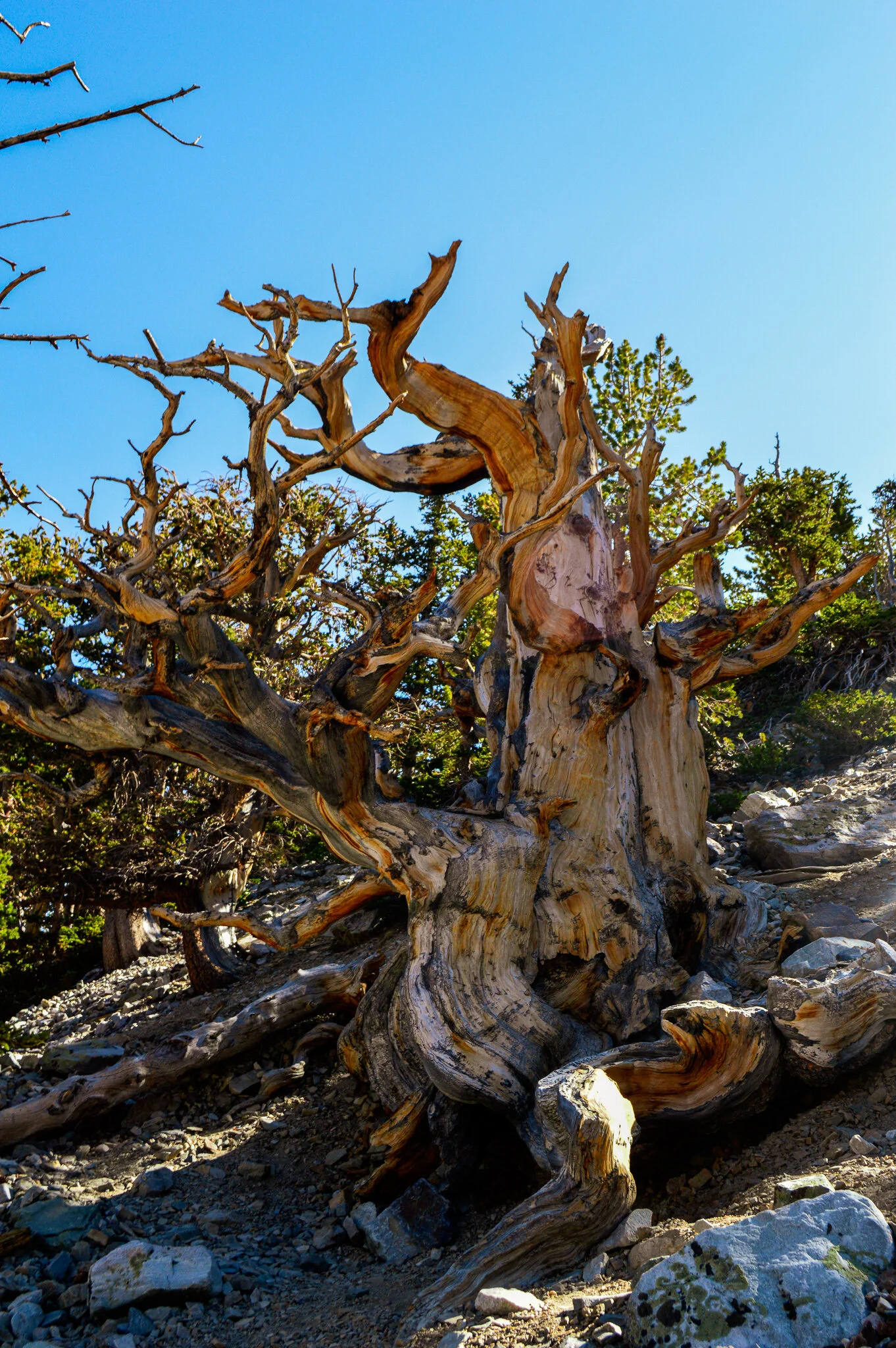
As you reach the final mile of the drive at 10,000 ft you are surrounded by groves of aspen, interspersed with the famous Great Basin Bristlecone Pines – the world's oldest trees. This remarkable tree is known for being the oldest non-clonal species on the planet, surviving for thousands of years. The now famous “Prometheus” was dated at over 4,900 years old before being cut down by a geographer doing research on ice age glaciology. These strange trees, shaped by the wind into almost human-like forms are extremely rare and found only in remote sections of California, Nevada, and Utah.
The scenic drive is actually one of the few ways to access the 13 maintained trails in the park. The Bristlecone trail and Sky Islands Forest trail begin at the end of the scenic drive and offer easy hiking with interpretive signs explaining the significance these forests and incredible ancient trees – a perfect evening hike for the kids to burn some energy and for the parents to learn!
The Bristlecone trail connects to the Glacier trail, which takes those willing to hike the extra 5 miles and 1500ft of elevation gain to Nevada’s only glacier. Wheeler Peak Glacier is one of the southernmost glaciers in the US and is a remnant from the past, showing a much different climate in a region that is now a desert. Sitting at the base of Wheeler Peak is a 2-acre alpine glacier that is the last of its kind to survive in this area. In fact, scientists predict the glacier will disappear in as little as 20 years. Indeed, hiking up to the remnants of the alpine glacier you realize that while there is technically still visible ice you can hike to, what you are actually seeing (and hiking on) up to that point is a rock glacier.


I had to do a bit of research on just what a rock glacier was, because when hiking on it, it seems pretty much like talus – really nothing remarkable. To be honest, I thought perhaps Nevada was confused on what a glacier is, ha! Rock glaciers do not look like glaciers at all – they are covered with thick layers of rock and debris. However, it is this rock and debris that shield the underlying ice from melting and allow it to persevere in areas where melt-rates are too high to sustain the more commonly thought of alpine glaciers. Inside rock glaciers, ice fills the spaces between the rocks and debris and it is long series of freezing, thawing, and sagging that allow the ice to work with gravity and provide enough force to move the debris and make these rock glaciers flowing masses.

Of course we could not leave the area without summiting the second tallest peak in the most mountainous state in the lower 48 – the 13,063 ft Mt. Wheeler. Trust me, coming from CO I had to fact check this statement, but it is in fact Nevada (not CO or CA) that contains more than 320 named mountain ranges and 172+ summits making it the second most mountainous state in the US, surpassed only by Alaska (but I digress). With only 8.2 miles round trip and a total gain of 2,900 ft, this hike felt like a walk in the park (ha!) for us. Providing excellent views of the basin and vistas filled with beautiful patches of fall foliage, we were frequently joined by mule deer as we made our way to the summit.

While the geology above ground is interesting, it is the cave system that truly distinguishes this park from others; an area that was closed when we visited due to COVID. With 42 caves filled with bulbous stalactites, rounded shields, and leaflike folia formations, it was a shame that we were unable to visit even the upper most caves. Though the USA Cave Animal of the year for 2020 is the Great Basin Cave Pseudoscropion, a little beastie we would have found alongside eyeless shrimp, packrats, and bats...so maybe we were spared a few “ick!” moments in the end? For those interested, there are virtual cave tours, but that doesn’t seem sufficient for us to feel like we have experienced this interesting topography. We will certainly need to make our way back to visit the Lehman Caves, and descend from the desert of ancient pines into magnificent, limestone rooms of translucent crystals and somewhat alien-looking mineral formations – an experience I’m sure the whole family will enjoy.


